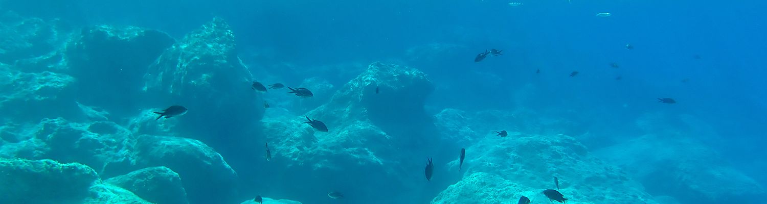
Author: astrid
Die heutige Gestalt Südeuropas ist durch die letzte der gebirgsbildenden Phasen im europäischen Raum bestimmt, die Alpidische Orogenese, in der die Alpen sowie die übrigen Gebirge des südeuropäischen Raumes entstanden. Diese gehören einem Gebirgssystem an, das sich vom Atlasgebirge in Marokko und den Pyrenäen aus über die Alpen und die Apenninen, die Balkanhalbinsel, die Ägäis, Anatolien, das Zagros-Gebirge im Iran und den Himalaja bis zur indonesischen Inselkette zieht....
The birds of Naxos
The material used in this article is based on information provided the foremost expert on the bird life of Naxos, the Greek ornithologist Nikos Promponas, as well as on a study of the breeding birds of Naxos conducted by Winfried Scharlau and myself in 1990, supplemented by more recent observations. I would like to express my thanks to Nikos Promponas for all his information and efforts, as well as to photographers Winfried Scharlau, Th. Gaitanakis and G. Beriatos for the...
Plattentektonik und Gebirgsbildung
Der Aufbau der Erde
Die Erde ist aufgebaut aus der dünnen Kruste (nur 0,7 % der Erdmasse), dem dicken Mantel und dem Kern, der etwa 30 % der Erdmasse umfasst. Der Kern besitzt einen festen inneren Bereich aus Eisen und Nickel und einen flüssigen äußeren Bereich aus Eisen und Schwefel. Der Mantel ist aus festem, aber fließfähigem Material aufgebaut. Er besteht vor allem aus dem Gestein Peridotit aus relativ silikatarmen, eisen- und magnesiumreichen...
Erdbeben
Griechenland ist die tektonisch aktivste Gegend Europas. Schon in der Antike hat man die häufigen Erschütterungen zu erklären versucht. Sie wurden in der Mythologie meist dem Meeresgott Poseidon zugeschrieben. Ab dem 6. Jahrhundert v. Chr. versuchten die ersten griechischen Philosophen natürliche Ursachen für die Beben zu finden. So glaubte Thales von Milet, dass die feste Erde auf dem Weltmeer schwimme und erzittere, wenn sich dieses bewege. Andere Philosophen...
The Vallonean oaks at Karkos near Apiranthos
A very beautiful hiking trail leads from Apíranthos via the fortified monastery of Fotodótis to Danakós. The path leads past a picturesque plateau called Karkós, where some magnificent old oak trees grow. Several old stone houses bear witness to the former use of this area. Today, the former vineyards are grazed by sheep. Right next to the grove on the slope of Mount Korakiá lies the small church Panagía Chrysopigí, which was originally a Mycenaean tomb.
looking over the...
Panagia Chrysopigi near Apiranthos
On a ridge named Korakiá south of Apíranthos lies a tiny church called Panagía Chrysopigí. It is a unique, very unusual building. The archaeologist Georgios Mastoropoulos concludes from the smallness of the building and the architecture and masonry which are quite unusual for a church, that the building was not originally built as a church but as a tomb, which may date back to the Mycenaean epoch.
The church lies about half an hour on foot from Apíranthos, near the pass to...
The Minoan epoch
Die minoische Epoche
Um 2000 v. Chr. nahm die charakteristische Kykladenkultur (3. Jahrtausend v. Chr.) ein Ende und die Minoer übernahmen in der Ägäis die Vorherrschaft. Entsprechend wird die nun beginnende Mittlere Bronzezeit auf den Kykladen als Minoische Epoche bezeichnet (2.000 bis 1.550 v. Chr.). Das ist insofern gerechtfertigt, als dass Kreta sich in dieser Epoche zu einer bedeutenden Großmacht entwickelte und die zumindest die näheren Inseln der Ägäis deutlich...
The volcano of Santorin
Unfortunately there is yet no translation available for some of the pages you find under the links below. Maybe try to translate the pages with Google translate (copy the URL and paste it into the field opening when you click on “websites”).
Die verschiedenen Typen des Vulkanismus
Es gibt (vereinfacht gesagt) drei Typen von Vulkanismus auf der Erde. Der erste Typ entsteht an der Grenze zwischen zwei auseinanderdriftenden tektonischen Platten: Hier dringt...
Am Fluss von Kinidaros 2
Einen Bericht über den Fluss nördlich von Kinídaros hatten wir ja schon, aber nun waren wir wieder da, und weil es so schön und einzigartig ist, kommen hier noch ein paar Fotos…
Der Ausgangspunkt des Spaziergangs ist wie immer die einzigartige steinerne Brücke.
Der Fluss ist einfach wunderschön…
…ein richtiger kleiner Urwald!
Hier wächst die Myrte (Myrtus communis), ein Gewächs, dass schon in der griechischen Mythologie als Pflanze der Aphrodite, der...
Agios Artemios near Kinidaros
South of mount Kóronos, from the village of Keramotí to Engarés on the coast, lies one of the steepest and deepest valleys on the island of Naxos. The valley is unusually rich in water: the most important of the island’s seven rivers flows here. To the north of Kinídaros in this valley lies a remarkable large 18th century church, dedicated to St Artémios, which is of interest for the history of the island.
The valley north of Kinídaros; the church Ágios Artémios...
The Venetian Castro in the Chora
The harbour town of Naxos, Chora, is crowned by the Venetian Castro, which covers a rather small area, but (according to the Naxos guide from Müller-Verlag) it is the only Venetian castle outside Italy that was never destroyed or conquered. To the area of the Castro belong several interesting churches, including the Catholic metropolis, but also several museums: the important Archaeological Museum of Naxos and the Venetian Museum, which also is well worth visiting, and a...
Dionysus and the island of Naxos
The following text is a revised and supplemented extract from my book “Zwei Türen hat das Leben” (=”The two doors of Life”).
The origin of the cult of Dionysus
The philhellenic historians of the last centuries were of the opinion that the god Dionysus did not belong to the original pantheon of the Greek gods, but was only brought to Greece later as a foreign, presumably oriental element by the Thracians. According to more recent findings, this view...
Naxos under the Venetians
IIn 1204, during the 4th Crusade, the Franks and Venetians conquered Constantinople, the capital of the Byzantine Empire, because the Emperor of Byzantium, who had called them to support him agains his enemies, was unable to pay the promised money. Constantinople was destroyed by the Crusaders, a catastrophe that led to an irreparable rift between the Orthodox and Catholic Church. The victors divided the conquered empire among themselves: France was awarded most of the...
The Chora
Unfortunately there is yet no translation available for this page as well as for descriptions of the hiking tours you find under the links below. Maybe try to translate the page with Google translate (copy the URL and paste it into the field opening when you click on “websites”).
Die Chóra von Naxos oder einfach “Naxos” ist die größte Ortschaft der Insel und besitzt den einzigen nennenswerten Hafen.
Die Chóra aus der Ferne; im Vordergrund die...
The Portara and the Temple of Apollon in the Chora
The best known symbol of the island of Naxos is the gigantic ancient portal of the Temple of Apollo in Naxos-Town, the Portára. It stands conspiciously on a small island “Palátia” that is connected by a pier to the Chóra and greets every visitor already at the arrival at the port.
view of the island of Palátia from the harbour
The small island is connected to the Chóra by a pier.
View from the Portára to the Chóra with the Venetian Kastro; in the background...
Snakes
Snakes are not very popular with most people. This is in part due to an instinctive fear that exists since millions of years, even though most snake species are completely harmless.
Like all reptiles, snakes are cold-blooded, which means that their body temperature depends on the ambient temperature. Accordingly, most snakes live in the warmer regions of the world. In Europe, most of the 27 snake species are restricted to the Mediterranean region. During the cold winter...
Agia Kyriaki und Schmirgelminen
Von Apiranthos aus kann man auf einem schönen, gut erhaltenen alten Wanderweg (Wanderweg 1) über die interessante kleine byzantinische Kirche Ágia Kyriakí zu den Schmirgelminen laufen, und von dort über einen kleineren Pfad bis nach Azalas zurück. Für die ganze Strecke braucht man etwa 4 bis 5 Stunden.
Der ausgeschilderte Wanderweg beginnt bei der Dorfkirche von Apiranthos; man geht unter der Straße Richtung Kóronos hindurch.
Dieses Schild weist auf die byzantinische...
Agia Kyriaki near Apiranthos
A particularly interesting Byzantine monument is the small church of Ágia Kyriakí north of Apiranthos. It dates from the 9th century AD, the time of the iconoclasm. Fortunately, in recent years the building has been restored (from the outside and the inside) at the initiative of the Cultural Association of Apiranthos as a collaboration of Swiss Byzantinologists and the Greek Byzantine Association. Since then it is – regrettably but understandably – locked, so...
The Kouroi of Flerio near Melanes
Close to the village of Mélanes lies a hill with marble of high quality that has been quarried since antiquity. The marble was used for the construction of buildings as well as for statues. Not too far away, marble is still being quarried today on a large scale. The area of Mélanes was inhabited since the Bronze age (3rd millennium BC), and its marble may have been used since then. Right next to the area of the antique marble quarry an excavated sanctuary of the springs...
The sanctuary at Flerio near Melanes
Near the well-known Koúros of Flerió (Mélanes) an ancient sanctuary has been excavated, in which the patron gods of the marble quarry and the nearby springs were worshiped. It is one of the oldest sanctuaries of the island, dating back to the Geometric epoch.
The small valley of Flerió is unusually rich in water. Although today there is no flowing river, several springs provide water all year round. The closest settlement is called Míli (Mills), after the watermills that...


